
Morning gathers slowly along Ridley Creek. Mist clings to the low fields near Okehocking, softening the tree lines and old stone walls before lifting into the woods. A deer steps cautiously from the edge of the preserve. Farther east, traffic begins to thicken near Malvern and the Main Line, but here the day still seems to open by degrees—quietly, deliberately, with the scent of damp leaves and pasture in the air.
Willistown Township lives in that contrast.
It sits close to some of the region’s most desirable suburban corridors, yet its identity remains rooted in something older: Lenape history, Welsh settlement, Quaker meetinghouses, covered bridges, village crossroads, and conserved landscapes that still hold their shape beneath the pressures of modern growth.
That balance matters now.
As development continues to reshape the western Main Line and eastern Chester County, Willistown offers a compelling example of a township that has grown prosperous without surrendering the landscapes that first defined it. Its preserved districts, historic roads, nature areas, and civic commitment to open space give the community a sense of continuity rare in a region where farmland and old villages have often yielded to speed, density, and convenience.
The story begins with the Okehocking people.
Long before the township was formally organized, the Okehocking band of the Lenni Lenape used this area as seasonal ground, living along wooded stream valleys and travel corridors that later influenced colonial roads. In 1702, William Penn granted the Okehocking a 500-acre reservation, one of the earliest formally surveyed Native land grants in Pennsylvania and a defining chapter in Willistown’s history.
The place still carries that memory.
The Okehocking Historic District preserves the landscape associated with that grant, including fields, stone walls, road alignments, and the Ridley Creek valley. Today, the Okehocking Preserve gives residents and visitors a rare opportunity to encounter Indigenous history not as an abstraction, but as a physical landscape—quiet, wooded, and deeply layered.
European settlement followed through the Welsh Tract.
Surveyed in the 1680s, the tract brought Welsh and English settlers into the region, shaping Willistown’s early farms, roads, and religious institutions. The township was formally organized in 1704, making it one of Chester County’s earliest municipalities. Roads such as Goshen, Sugartown, and Boot emerged early, often building upon older travel corridors and connecting farms, mills, churches, and crossroads villages.
Those crossroads remain central to Willistown’s identity.
Sugartown is one of the township’s most evocative examples. Its historic district preserves a rural service village where taverns, stores, schools, tradesmen’s shops, and the old township building once supported the surrounding farm community. The architecture is modest and cohesive, but its power comes from the whole scene: roads meeting, buildings holding their corners, fields still close enough to remind visitors why the village existed.
White Horse tells a similar story along another historic road.
The White Horse Historic District preserves a linear village landscape shaped by travel, farming, and the old White Horse Tavern. Stone and frame buildings still mark the route where stagecoaches, wagons, and local residents once moved between farms and markets. It remains one of those places where the township’s older geography can still be read from the road.
Bartram’s Covered Bridge adds another layer of memory.
Built in 1860, the red Burr-arch truss bridge spans Crum Creek at the Willistown-Newtown Township line. Closed to vehicular traffic but open to pedestrians, it remains one of the region’s most beloved historic crossings—a quiet reminder of a time when bridges were built not only for passage but with craftsmanship that left beauty behind.
The township’s Quaker heritage is equally visible.
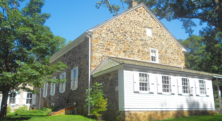
Willistown Friends Meeting House, rooted in a 1753 meeting and housed in its present 1798 stone building, reflects the plainness and endurance of early Friends communities. Set beside its burial ground and shaded by mature trees, it remains an understated anchor of the township’s colonial-era settlement pattern.
Willistown’s historic resources are not limited to landmarks.
They are landscapes.
Garrett Farmstead, the Okehocking district, Sugartown, White Horse, and the preserved creek valleys all depend on context. Their meaning comes from the relationship between buildings, roads, fields, walls, and water. That relationship is what makes Willistown feel distinct from more conventional suburbs.
It is also what makes preservation here so important.
The township’s affluence is evident in its home values, high owner-occupancy, and strong educational attainment. But its deeper civic value lies in the deliberate effort to retain open space, protect historic districts, and maintain a low-density landscape even as the Main Line’s influence presses westward.
Nature reinforces that identity.
Ridley Creek and Crum Creek shape wooded corridors and wildlife habitat, while Okehocking Preserve and other conservation lands give residents access to quiet trails and open fields. These spaces help make Willistown more than a desirable address. They make it a community with texture, memory, and room to breathe.
Its public figures reflect the township’s layered character.
William Evans and Nathaniel Grubb connect Willistown to Pennsylvania’s long traditions of rural governance and civic service. Edward L. Stokes links the township to Depression-era national politics. M. Night Shyamalan, who has maintained a creative base in Willistown, connects the community to contemporary filmmaking and the broader cultural identity of southeastern Pennsylvania.
Together, they suggest a township shaped by both privacy and influence.
Willistown is not showy.
Its history is not concentrated in a single downtown or monument. It is dispersed across meetinghouses, preserves, crossroads, estates, roads, and farm lanes. The reward comes to those who move slowly enough to notice.
As evening settles over Okehocking, the last light catches the tops of the trees above Ridley Creek. The preserve grows quiet. Along old roads, stone walls fade into shadow, and the fields beyond Sugartown soften in the dusk.
The Main Line is close.
The land is closer.
And in Willistown Township, that enduring nearness to field, creek, road, and memory remains the story that gives the community its soul.
Support the local news that supports Chester County. MyChesCo delivers reliable, fact-based reporting and essential community resources—free for everyone. If you value that, click here to become a patron today.