
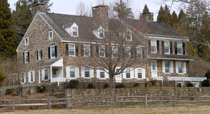
Morning fog hangs low along Conestoga Road as sunlight filters slowly through the trees. The winding pavement bends past old stone farmhouses, weathered fence lines, and dense stretches of woodland where the hills seem to close tightly around the road. In some places, the forest presses so near the shoulder that it feels as though the landscape is reclaiming the route inch by inch.
Traffic is light enough here that silence still dominates.
A pickup truck disappears around a curve. Somewhere deeper in the woods, a woodpecker rattles against a dead oak. The smell of damp leaves and moss drifts up from the French Creek watershed, carrying the coolness of a landscape that has remained remarkably untouched compared with much of southeastern Pennsylvania.
East Nantmeal Township has always existed slightly apart from the region around it.
While neighboring parts of Chester County steadily suburbanized, East Nantmeal retained the rugged rural character that first drew Welsh Quaker settlers here in the early 1700s — rolling farmland folded into dense hardwood forest, narrow colonial roads, and isolated homesteads tied historically to iron production, timber, and agriculture. Even today, with development pressure spreading steadily outward from Philadelphia’s suburbs, the township remains one of northern Chester County’s quietest and least altered landscapes.
That preservation is not accidental.
East Nantmeal sits partly within Hopewell Big Woods, the largest contiguous forest remaining in southeastern Pennsylvania, a conservation landscape stretching across more than 73,000 acres. The forested ridges, stream valleys, and headwaters surrounding French Creek have become increasingly important in a region where open land grows scarcer each year.
“You can still disappear out here,” says a longtime resident whose family has lived near Fairview Road for generations. “There are places where the woods feel older than the roads.”
In many ways, they are.
The township’s identity traces back to Welsh Quaker settlers who arrived in the early 18th century, naming the area “Nantmeal” after a village in Radnorshire, Wales. Early communities formed around meetinghouses, mills, farms, and eventually the iron industry that would shape much of northern Chester County’s economy.
The region possessed everything early ironmasters needed: dense hardwood forests for charcoal production, flowing streams for waterpower, and nearby deposits of iron ore and lime. Families such as the Rutters, Potts, Savages, and Van Leers transformed the surrounding countryside into a network of forges, charcoal sites, wagon roads, and agricultural settlements tied directly to early American industry.
Even now, remnants of that world remain embedded in the landscape.
Conestoga Road, now designated PA 401, still follows much of its original colonial alignment across East Nantmeal’s hills and valleys. The narrow road once carried wagons loaded with charcoal, pig iron, and farm goods eastward toward Philadelphia markets. Today it winds quietly through forests and open fields, preserving the physical rhythm of an 18th-century transportation corridor.
Unlike modern highways engineered for speed and efficiency, Conestoga Road still feels shaped by terrain rather than imposed upon it.
Stone walls appear unexpectedly beside the road. Farmhouses sit close to the pavement at odd angles inherited from centuries-old property lines. Sharp bends reveal long wooded ridges rolling toward the horizon.
At the Nantmeal Friends Meeting Cemetery on Fairview Road, that sense of continuity becomes especially tangible.
Hidden behind a low stone wall shaded by mature trees, the small burial ground remains the last surviving remnant of the 1739 Nantmeal Friends Meeting. The meetinghouse itself disappeared generations ago, but the cemetery endures quietly among the hills, its plain Quaker grave markers reflecting the simplicity and restraint that defined the area’s earliest settlers.
The silence there feels unusually complete.
No commercial development interrupts the view. No dense subdivisions rise beyond the tree lines. The landscape still holds enough open space to preserve not only the township’s appearance, but its atmosphere.
That atmosphere increasingly defines East Nantmeal’s modern identity.
Though the township remains lightly populated — fewer than 2,000 residents spread across more than 16 square miles — its rural character has become one of its greatest assets. Conservation efforts tied to Hopewell Big Woods and the French Creek watershed have helped preserve forests, wildlife corridors, and historic landscapes that might otherwise have fragmented beneath suburban expansion.
The result is a place where environmental preservation and historical continuity overlap almost seamlessly.
Along the forested slopes surrounding French Creek, hikers, birdwatchers, and cyclists now move through landscapes once dominated by charcoal burners and iron wagons. Old farmsteads remain visible through breaks in the trees. Narrow roads still connect settlements whose names have survived since the colonial period.
And when evening settles across East Nantmeal, the township grows remarkably dark.
Mist gathers low in the valleys near French Creek while the last light fades behind wooded ridgelines. Along Conestoga Road, headlights briefly illuminate old stone walls before disappearing again into the trees.
For a moment, the landscape feels suspended outside modern time — still shaped more by forest, water, and history than by the rapid pace unfolding beyond its borders.
Support the local news that supports Chester County. MyChesCo delivers reliable, fact-based reporting and essential community resources—free for everyone. If you value that, click here to become a patron today.