Morning arrives slowly in Newlin Township. Mist rises from the West Branch of the Brandywine Creek and drifts across meadows bordered by centuries-old stone walls. Along Route 162, the creek bends through wooded hillsides where sycamores lean over the water and trout ripple the surface beneath their branches. A red-tailed hawk circles above a patchwork of fields before disappearing beyond the ridgeline. Here, the landscape unfolds gradually, revealing itself through winding roads, hidden farm lanes, and valleys that seem untouched by time.
A few miles downstream, the stone buildings of Embreeville catch the early light. Across the creek, weathered mill structures and historic homes stand where generations once harnessed waterpower to grind grain, shape iron, and sustain a rural economy. The sound of rushing water remains constant, linking the present to a past that still feels remarkably close.
In a county known for balancing growth and preservation, Newlin Township occupies a singular place. Home to just over a thousand residents, it remains one of Chester County’s most rural municipalities, a landscape where history is preserved not only in buildings but in entire valleys, roads, and viewsheds. At a time when development pressures continue to reshape much of southeastern Pennsylvania, Newlin has become a living example of how conservation, heritage, and community identity can remain intertwined.
Its story begins with a creek.
When Quaker settler Nicholas Newlin received land from William Penn in the late 17th century, the Brandywine Valley was still largely defined by forests, waterways, and Lenape trails. In 1724, his son Nathaniel acquired a massive 7,750-acre tract that would become Newlin Township, selling parcels to settlers who quickly recognized the power of the water. Soon, early industrial enterprises like Marshall’s Mill and the Embreeville Mill appeared along the banks, using the steady flow of the Brandywine and its tributaries to power economic growth.
The creek shaped nearly everything that followed.
Settlements emerged along its banks. Roads followed its contours. Families built farms on fertile bottomlands and ridges overlooking the water. Generations earned their livelihoods from the landscape while remaining deeply connected to it.
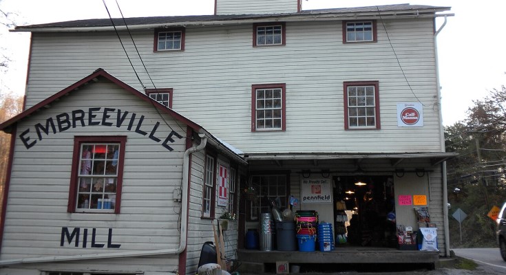
That connection is visible throughout the township today.
The Embreeville Historic District preserves one of the most intact mill villages in the Brandywine Valley. Stone and stucco buildings cluster around a dramatic bend in the creek, where mills once served as the economic center of the community. A blacksmith’s house, wheelwright’s shop, miller’s residence, and country store remain standing, their architecture reflecting a time when nearly every necessity of daily life could be found within walking distance.
The setting feels almost theatrical.
Steep wooded slopes rise behind the village. The creek narrows and widens as it winds through the valley. Historic buildings appear unexpectedly around bends in the road, creating a sense of discovery that modern development rarely provides.
Elsewhere, entire landscapes have survived with extraordinary integrity.
The Green Valley Historic District encompasses hundreds of acres of farmland, stone houses, school buildings, mill sites, and agricultural outbuildings dating from the late 18th and early 19th centuries. Unlike many historic districts that preserve individual structures, Green Valley preserves an entire rural environment, allowing visitors to experience the relationship between architecture, agriculture, and landscape much as early residents would have known it.
The same is true at Northbrook.
There, the Brandywine sweeps through a broad bend surrounded by floodplain farms and wooded hills. Historic buildings stand near archaeological sites linked to both Indigenous communities and early settlers. The landscape reflects layers of human history stretching back centuries, each generation leaving traces without erasing what came before.
Perhaps nowhere is that continuity more evident than in the story of Hannah Freeman.
Known locally as Indian Hannah, Freeman is remembered as the last Lenape resident of Chester County. Born around 1730, she spent much of her life moving through the creek valleys and woodlands that now define Newlin Township. A healer, basketmaker, and laborer, she maintained relationships with local Quaker families even as Indigenous communities were displaced from their ancestral lands.
Her story remains woven into the landscape.
At Northbrook, the site of her cabin and nearby Indian Rock serve as reminders that the history of the Brandywine Valley began long before European settlement. The creeks, forests, and meadows that drew settlers had sustained Indigenous communities for generations.
Newlin’s history also reaches far beyond Chester County.
Near Embreeville stands the Harlan House, known as Stargazer’s Farm. During the winter of 1764–65, surveyors Charles Mason and Jeremiah Dixon used the property as their base while conducting the measurements that would establish the Pennsylvania-Maryland boundary. Nearby, Stargazer’s Stone still marks the location where they made astronomical observations to determine the precise latitude that guided one of the most important surveying projects in American history.
The landscape inspired other remarkable lives as well.
Josiah Harlan, born in Newlin Township in 1799, left the Brandywine Valley for adventures that carried him across Central Asia, where he became a physician, diplomat, military adviser, and, improbably, a prince in Afghanistan. Botanist William Baldwin developed his lifelong fascination with plants while growing up near the Brandywine. Hettie Kersey Painter, raised in the township, went on to serve as a Civil War nurse and physician at a time when few women entered the medical profession.
Yet despite these extraordinary stories, Newlin remains defined less by famous individuals than by the landscape itself.
The township’s economy has shifted from mills to residences, horse farms, and conservation-focused land use. Open-space preservation and historic protections help maintain the rural character that residents value. Meadows bloom with native grasses. Mountain laurel flourishes on wooded slopes. The Brandywine and its tributaries continue to support wildlife and shape the rhythm of life.
As evening settles over Newlin Township, shadows lengthen across the creek valleys. The stone walls of old farmhouses glow softly in the fading light. Along the Brandywine, the water reflects the last colors of the sky before darkness settles over the hills.
The creek keeps moving, just as it has for centuries.
And in its bends and valleys, Newlin Township continues to preserve something increasingly rare—not merely historic buildings or protected acreage, but an entire landscape where the past remains visible in the contours of the land itself.
Support the local news that supports Chester County. MyChesCo delivers reliable, fact-based reporting and essential community resources—free for everyone. If you value that, click here to become a patron today.